By Michael Nielsen, Editor & Publisher | 15+ Years in Diesel Repair & Fleet Operations
A truck GPS app is navigation software built specifically for commercial vehicles — routing around low bridges, weight-restricted roads, and no-truck zones based on a driver's actual vehicle dimensions, rather than treating a Class 8 rig like a passenger car. For an owner-operator, the difference between a truck GPS app and a consumer mapping app isn't convenience — it's the gap between a route that's legal and safe for an 80,000-pound vehicle and one that isn't. Heavy Duty Journal's technicians and fleet contacts see the same routing mistakes repeatedly: a driver trusts a phone's default map, and a "fastest route" turns into a low-bridge strike, a fine, or an unplanned detour that burns hours of drive time. Choosing the right truck GPS app means evaluating a short list of features that actually matter on the road — not just screen design or brand recognition.
Key Takeaways
- Truck-specific routing that accounts for height, weight, length, axle count, and hazmat classification is the single non-negotiable feature — everything else is secondary.
- Truck parking data is the feature owner-operators report using most, and the one most likely to determine where a driver's day actually ends.
- Fuel and DEF price comparisons built into a routing app can offset a meaningful share of a truck GPS app's subscription cost over a year of driving.
- Offline map access matters in any corridor with unreliable cellular coverage — mountain routes, rural agricultural corridors, and parts of the oil patch among them.
- A paid, truck-specific app is generally worth the cost for anyone driving professionally every day; free consumer apps carry real compliance and safety risk for commercial vehicles.
Why Consumer GPS Apps Fall Short for Commercial Trucks
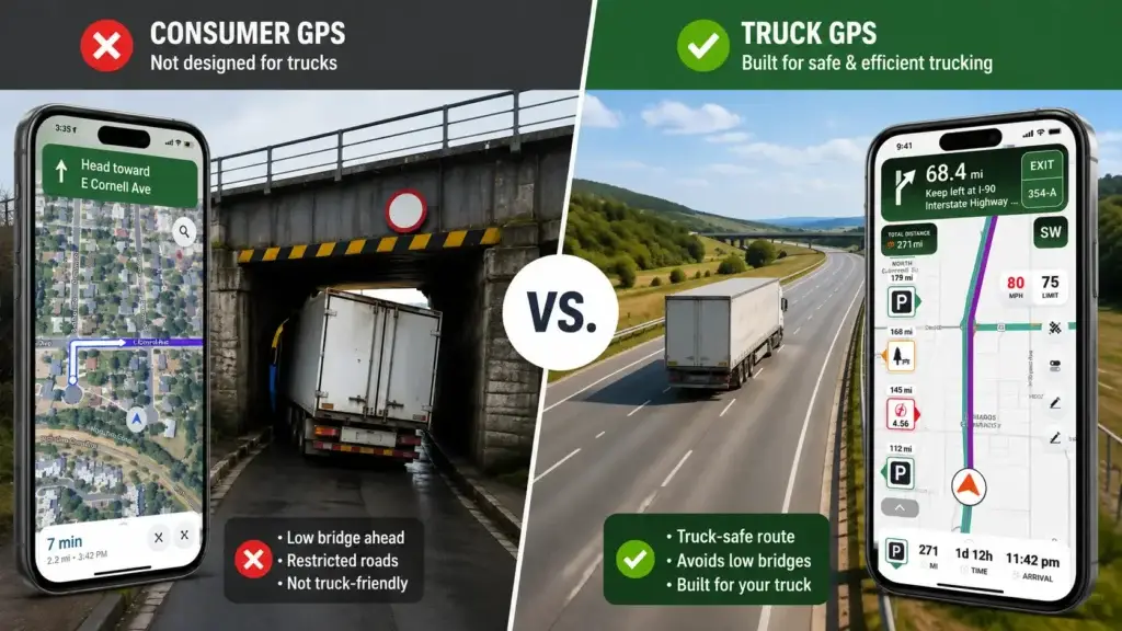
Google Maps and Waze are built around a single assumption: the vehicle is a passenger car. Neither app asks for a vehicle's height, weight, or axle configuration, and neither one factors in a "No Trucks" restriction, a weight-limited bridge, or a hazmat-prohibited tunnel when it calculates the fastest route. That gap is well documented at the federal level. FMCSA has stated publicly that a share of truck-versus-bridge incidents traces back to drivers using navigation systems designed for passenger vehicles rather than commercial ones, and the agency has spent years urging carriers and drivers toward truck-specific systems for exactly that reason.
The practical risk isn't hypothetical. A truck that's routed under a bridge it can't clear doesn't just cause property damage — it can shut down a rail line or highway for hours, trigger a citation, and follow the carrier's safety record for years afterward. A route that ignores a bridge formula weight restriction can put a driver out of compliance before they even realize it. Consumer apps aren't defective; they're simply solving a different problem than the one a commercial driver actually has.
Truck-Specific Routing: The Baseline Feature, Not a Bonus
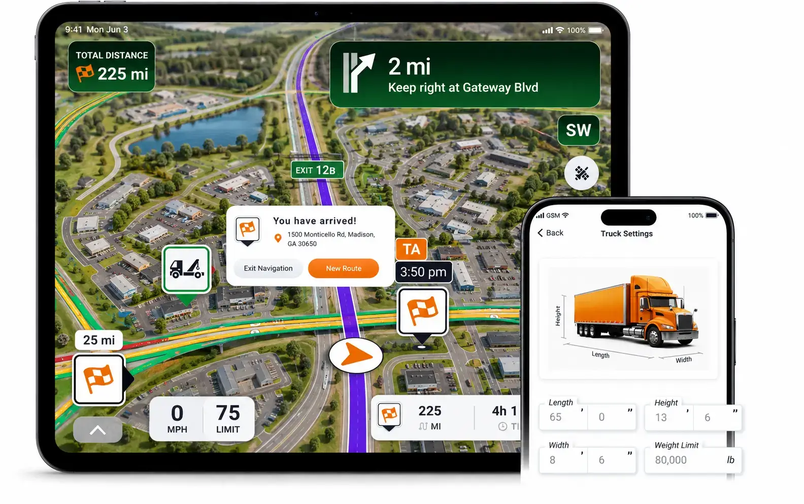
Before comparing any other feature, confirm the app supports a real vehicle profile. A driver should be able to enter height, gross vehicle weight, trailer length, number of axles, and hazardous materials classification, and have the routing engine actually use that data — not just display it. The regulatory backdrop here is real: federal size and weight limits under 23 CFR Part 658 cap gross vehicle weight and set axle weight limits that vary by bridge and route, and a truck that's compliant on one road can be over-limit on the next if the app doesn't recalculate around those restrictions. Drivers hauling hazardous materials face an added layer — the Hazardous Materials Regulations under 49 CFR Parts 171–180 govern which roads, tunnels, and urban corridors are off-limits to certain hazmat classes, and a routing app that doesn't build hazmat restrictions into its base routing logic is putting that compliance burden entirely back on the driver.
For fleet managers and owner-operators evaluating routing platforms, a truck GPS app like Trucker Guide that accepts a complete vehicle profile — and actually recalculates around it rather than treating those fields as decoration — is the baseline test for whether a tool belongs in a commercial cab at all. Anything short of that is a consumer app with a trucking-themed skin.
Beyond the profile fields themselves, look at how the app handles toll roads, ferries, tunnels, and unpaved roads. A driver running a regular lane with tight margins on time and fuel needs the ability to exclude route types that don't fit their equipment or their carrier's policy — not just avoid them manually after the fact.
Truck Parking Data Matters More Than the Map Itself
Ask any long-haul owner-operator what frustrates them most about a shift, and truck parking will come up before fuel prices or traffic. The shortage isn't a minor inconvenience — research from the American Transportation Research Institute has found there is roughly one public truck parking space for every 11 truck drivers nationally, and driver parking diaries collected by ATRI have shown drivers spending close to an hour a day searching for a legal spot to park — time that comes directly out of a limited daily drive-time budget under Hours of Service rules.
That's why parking data deserves real weight when comparing truck GPS apps. A driver who delays the search for parking until the final 30 minutes of legal driving time is gambling on finding something before running out of hours. A navigation app that surfaces truck stop and rest area data, live occupancy signals, and amenities (showers, food, fuel) well before arrival turns that gamble into a planned stop. The size of the underlying database matters here — an app with a shallow, outdated list of truck stops is only marginally better than no data at all.
What to Look For in Parking Data
- Live or recently updated occupancy status, not just static location pins
- Coverage of rest areas and weigh stations in addition to commercial truck stops
- Amenity details — showers, food service, fuel brand, overnight parking policy
- Community-reported updates that reflect real-time conditions rather than a database refreshed annually
Fuel and DEF Price Comparison Along the Route
Fuel is the single largest recurring operating cost for most owner-operators, and a navigation app can't move the market price of diesel — but it can put price comparisons directly in front of a driver before they commit to a stop. Rather than defaulting to the first truck stop on the route, a driver comparing prices across two or three nearby stations can capture real savings that add up over a full year of driving. The same principle applies to DEF pricing, which fluctuates by station in ways that are easy to miss without a dedicated comparison view.
Individually, the savings from any single stop are modest. Multiplied across hundreds of fuel stops a year, differences in price, unnecessary mileage from a poorly chosen route, and idle time waiting in line at a crowded island become a real line item on an owner-operator's bottom line.
Live Weather Alerts and Road Conditions
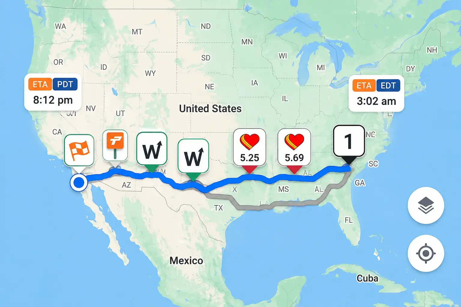
Weather changes fast on long interstate runs, and a standard forecast only tells part of the story. Crosswinds strong enough to affect a high-profile trailer, flash flooding on a low-lying stretch of highway, or an early-season snow event can turn a normal run into a genuinely dangerous one with little warning. A truck GPS app worth using surfaces route-specific weather alerts, not just a generic forecast for the driver's current city, and gives enough lead time to adjust a route or hold at a safe location rather than finding out about deteriorating conditions from a wall of brake lights ahead.
Live road camera access adds useful context here. A forecast describes what conditions are expected; a camera feed shows what's actually happening on the ground a few hundred miles ahead — genuinely useful information when road conditions change faster than a static route plan can account for.
Seasonal timing matters too. A route through mountain grades that's routine in July can turn into a chain-up delay or a full closure in a January storm, and a driver who hasn't checked route-specific alerts before departure may not find out until they're already committed to a grade with nowhere to turn around. Building a habit of checking weather and road-condition alerts at the start of every shift — not just when conditions already look questionable — closes that gap before it becomes a problem.
Offline Maps: Non-Negotiable for Certain Routes
Cellular coverage isn't universal, and the gaps aren't rare. Mountain passes, long stretches of rural agricultural corridor, and parts of the oil patch in Texas, New Mexico, and North Dakota routinely drop signal for extended stretches. A truck GPS app that requires a live connection to function is a liability on those lanes — the moment signal drops, the driver loses navigation entirely, often at the worst possible time to be without it.
Downloading maps for a planned route before departure removes that risk. It's a small step that costs nothing but a few minutes of prep time, and it's the difference between staying on a planned route through a dead zone and driving blind through unfamiliar territory with no routing assistance at all.
The HDJ Perspective
Most owner-operators evaluate a truck GPS app on routing accuracy alone and treat parking and fuel data as nice-to-haves. In 15+ years around fleet operations, the pattern I've seen run the other way: routing engines from the major truck-specific providers are all reasonably competent at avoiding low bridges and weight-restricted roads at this point — that problem is largely solved. The feature gap that actually separates a good app from a mediocre one, day to day, is how well it handles the unglamorous stuff: parking data that's actually current, fuel comparisons that save real money, and offline maps that don't fail exactly when a driver needs them most.
Workflow Integrations: ELDs, Load Boards, and Dispatch
Navigation is one piece of an owner-operator's daily workflow, not the whole thing. Most independent drivers already juggle an electronic logging device, a load board app, a dispatch or messaging tool, fuel cards, and maintenance logs. Some truck GPS apps integrate with one or more of those tools, cutting down on how often a driver has to switch between apps mid-shift — a small but real reduction in distraction while driving.
Not every integration will matter to every driver. A solo owner-operator running the same handful of lanes has different needs than a driver working through a load board daily. It's worth checking which integrations a given app actually supports rather than assuming broad compatibility, since this is an area where marketing claims and actual functionality can diverge.
Integrations Worth Checking For
- ELD compliance apps — reduces the number of separate screens a driver has to monitor while running a route
- Load board apps — useful for drivers who plan a next load around where a current route ends
- Fuel card platforms — ties fuel price comparison directly to discounts already available through a driver's card
- Maintenance and service reminders — some platforms surface upcoming PM intervals alongside route planning, though this is a less common integration
The value of any single integration depends on how a driver already runs their business. A driver who dispatches themselves and rarely touches a load board gets little benefit from that particular connection, while a driver constantly bouncing between apps to find the next load may find it worth paying more for a platform that consolidates several of these functions.
Free vs. Paid Truck GPS Apps: What the Subscription Buys
Whether a paid app is worth the cost depends heavily on how often a driver is on the road and which features actually get used. The table below breaks down the general pattern.
| Feature | Free Apps | Paid Truck GPS Apps |
|---|---|---|
| Routing basis | Basic navigation, often car-based | Full truck-specific routing profile |
| Restriction handling | Limited or none | Height, weight, and hazmat restrictions built in |
| Traffic data | Basic | Advanced, with live rerouting |
| Trucking-specific tools | Few or none | Parking, fuel pricing, weather, and hazmat routing |
A driver running professionally every day tends to recoup a paid subscription quickly, often through a single avoided routing mistake or a modest reduction in fuel spend across a month of driving. A driver making occasional trips has a weaker case for a paid tier, though the safety and compliance argument for truck-specific routing still applies regardless of how often someone drives.
Free Professional Fleet Tools
Cost calculators, fault code lookup, maintenance planners, and more — built for owner-operators, fleet managers, and diesel techs. No signup required.
A Practical Checklist Before You Choose
Before settling on a truck GPS app, run through a short list of questions rather than picking based on app store ratings alone:
- Does it support a full truck-specific routing profile — height, weight, length, axles, and hazmat class?
- Does it include current, detailed truck parking data, not just a static list of truck stops?
- Are fuel and DEF price comparisons built in, or is that a separate app?
- Does it provide route-specific weather alerts, not just a general forecast?
- Can it be used offline in areas with no cellular coverage?
- Does it integrate with the ELD, load board, or dispatch tools already in use?
- Does the subscription cost make sense against how often the vehicle is actually on the road?
Not every feature carries equal weight for every driver. A regional driver running the same handful of lanes may not need offline maps as urgently as a long-haul driver crossing the Rockies. The right answer depends on the freight being hauled, the routes being run, and how much information a driver wants available in a single app rather than spread across several. Heavy Duty Journal's broader fleet-technology coverage at heavydutyjournal.com walks through similar evaluation frameworks for other in-cab tools, if it helps to see the same logic applied elsewhere.
It also helps to separate must-haves from nice-to-haves before comparing specific apps. Truck-specific routing and accurate restriction handling belong in the must-have column for any commercial driver — there's no real substitute, and the compliance and safety exposure of skipping it is too high to justify on price alone. Parking data, fuel comparisons, and workflow integrations are where personal priorities should drive the decision, since the right mix genuinely varies by the type of freight, the regularity of the routes, and how much a driver values consolidating tools into one app versus running several specialized ones side by side.
Frequently Asked Questions
What makes a GPS app a truck GPS app instead of a regular navigation app?
A truck GPS app builds routing decisions around a vehicle profile — height, weight, length, axle count, and hazmat classification — and uses that profile to avoid low bridges, weight-restricted roads, and prohibited zones. A standard consumer app has no vehicle profile at all and routes every user the same way, regardless of what they're driving.
Is a free truck GPS app good enough for occasional driving?
A free, genuinely truck-specific app can be a reasonable starting point for light or occasional commercial driving, provided it still applies real height, weight, and hazmat restrictions to its routing. The bigger risk is a free app that markets itself as "for trucks" but doesn't actually build those restrictions into its routing engine — that's effectively a consumer app with different branding.
How much does truck parking data actually matter compared to routing accuracy?
For most long-haul owner-operators, parking data matters just as much as routing accuracy, if not more, because of how tightly it interacts with Hours of Service limits. A driver who can't find legal parking before running out of drive time faces a forced, often unsafe stop — a problem good routing alone doesn't solve.
Can a truck GPS app work without cell service?
Many truck-specific apps support offline maps that can be downloaded before a trip, which keeps routing functional through dead zones on mountain routes, rural corridors, and remote drilling regions. Not every app offers this, so it's worth confirming before relying on an app for a route with known coverage gaps.
Do truck GPS apps help with hazmat routing compliance?
Apps that build a hazmat classification into the routing profile can help a driver avoid roads, tunnels, and urban corridors that are restricted for certain hazard classes under federal hazardous materials regulations. That said, the app is a tool, not a substitute for a driver's own knowledge of hazmat routing requirements — final compliance responsibility stays with the driver and carrier.
Choosing a truck GPS app comes down to one question: does the information it provides make a given route more practical for the vehicle, the load, and the day's actual conditions — not just whether it can calculate turn-by-turn directions from point A to point B. As Heavy Duty Journal's Michael Nielsen has found after 15+ years around fleet operations, the apps that earn a permanent spot on a driver's dashboard are the ones that get the unglamorous details right: current parking data, real fuel savings, and routing that holds up when cell service doesn't. For more on evaluating fleet technology, Heavy Duty Journal's ongoing coverage at heavydutyjournal.com digs into how these tools fit into a broader fleet management strategy.
Know an Owner-Operator Still Using a Consumer GPS?
Pass this along to any driver still routing with a passenger-car app — the parking, fuel, and hazmat routing gaps covered here are the ones that actually cost time and money on the road.